Isn’t it ironic, the western states of our country are burning up with hundreds of fires and thousands of firefighters struggling to put them out, while here in MA, MassWildlife started 17 of them on purpose across the Commonwealth. The purpose was to improve wildlife habitat.
Over 560 acres within MassWildlife’s Wildlife Management Areas have received fire management thus far statewide. As part of a pilot project approved by the Executive Office of Energy and Environmental Affairs, MassWildlife was able to utilize a new tool this year to monitor and inform its habitat management. Unmanned Aircraft Systems (also known as UAS or drone technology) provide high-resolution imagery which allows them to monitor habitat conditions before, during, and after prescribed fire events. The multi-rotor UAV used looks similar to a helicopter with multiple rotors, allowing for easy take-off and landing.
UAS technology improves their situational awareness during a prescribed fire by using real-time videography and thermal imagery to understand where smoke, fire, and hot spots occur. The imagery produces very high-resolution georeferenced maps and photos of vegetation and landscape patterns. After a fire, MassWildlife is able to use the images to evaluate fire effects and revegetation to improve fire management practices and manage important habitat for wildlife over time. MassWildlife considers itself fortunate to partner with the skilled licensed UAS pilots with the MassDOT Aeronautics Program to capture unique aerial views of prescribed fire and other pilot sites across Massachusetts where different habitat management and monitoring activities are taking place. This gives them the ability to quickly note changes in vegetation over time and document progress toward MassWildlife’s desired habitat management goals. They have a video clip which shows a prescribed fire conducted by MassWildlife in collaboration with their partners within DCR Fire District 9 and Montague Center Fire Department at Montague Plains Wildlife Management Area this spring. 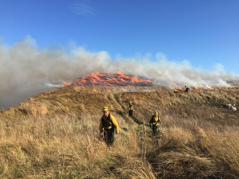
When appropriately timed and carried out, prescribed fires produce spectacular results in a variety of habitats; removing thatch or leaf litter, removing hazardous fuels, promoting warm season grasses and herbs and eliminating woody encroachment or undesirable plants. These improvements provide critical habitat for many targeted wildlife and fire-adapted plants.
It has been a busy and successful spring prescribed fire season for MassWildlife and they wish to thank their skilled prescribed burn crew, as well as their many fire management partners including Mass DCR Bureau of Forest Fire Control, the National Park Service Cape Cod National Seashore, US Fish and Wildlife Service, local Fire Departments and many other dedicated prescribed fire volunteers.
While they have taken a short summer hiatus from burning to catch up on monitoring, reporting, and other important tasks, MassWildlife has many prescribed burns planned for late summer and fall.
Isn’t it interesting how history repeats itself. The idea of controlled burns is nothing new, in fact it is widely believed that the native Americans of Massachusetts used to do the same thing, years ago, long before the European settlers “discovered” these lands. The prescribed burning at Montague Plains and dozens of other conservation areas across New England is based on the belief that, for thousands of years, Native Americans cleared forests and used fire to improve habitat for the plants and animals they relied upon.
However; new research published in a January 2020 article in the journal Nature Sustainability, (“Native people did not use fire to shape New England’s landscape”) tests this human-centric view of the past using interdisciplinary, retrospective science. The data they collected suggest, in New England, this assumption is erroneous.
In the field of paleo-ecology, researchers take advantage of the fact that, over time, the bottoms of lakes and ponds fill up with mud. Using hand-driven devices, scientists can collect a cylindrical core of the sediment and then use radiocarbon dating to determine the age of the mud at different depths. According to the Journal, over the last century, scientists have collected sediment cores from hundreds of lakes around the world, enabling them to reconstruct past environments and ecosystems. They have analyzed the mud in some study ponds, and found the obvious signature of forest clearance by 17th-century European colonists. Pollen from forest species declined, while pollen from agricultural and weedy species, like ragweed, increased abruptly. They believe this evidence clearly shows New England’s open land habitats owe their existence to Colonial European deforestation and agriculture, especially sheep and cattle grazing, hay production, and orchard and vegetable cultivation in the 18th and 19th centuries.
The Journal article goes on to say, “This retrospective research should cause some conservationists to reconsider both their rationale and tools for land management. If the goal is to emulate the conditions that existed prior to the arrival of Europeans, land managers should allow New England forests to mature with minimal human disturbance. If the goal is also to maintain biodiverse open land habitats, like Montague Plains, within the largely forested landscape, managers should apply the Colonial-era agricultural approaches that created them nearly 400 years ago. Those tools would include mowing, grazing and cutting woody vegetation – but not burning.” “Sediment tells the story”, they say.
Personally, I’m a strong believer in open biodiverse land habitats and don’t particularly care how they achieve them…………as long as they don’t let those controlled burns get out of hand!
Martin Feehan is the new deer and moose biologist for the Massachusetts DFW
![]()
Martin began his new job in May 2021. It includes overseeing the biological data collection, abundance estimation, and management of deer and moose within the Commonwealth. His primary focuses for the coming years include expanding deer hunting access in suburban communities throughout central and Eastern Massachusetts, maintaining deer populations within goals for Western zones, and screening for emerging diseases.
Feehan is from Milwaukee, Wisconsin and graduated with a bachelor’s of science degree from University of Wisconsin – Madison in 2014, with majors in evolutionary biology, wildlife ecology, and an environmental studies certificate from the Nelson Institute. A significant portion of time during this period was spent working at Wisconsin Department of Natural Resources deer check stations, screening for Chronic Wasting Disease. Following graduation, Feehan worked for the USGS on Piping Plover in Montana and grizzly bear research for University of Alberta just outside of Jasper National Park. Since 2016, Feehan has been a PhD student at Cornell University in New York with his research focusing on urban deer population ecology at Fort Drum. This has included intensive deer capture of 500+ deer and trail camera surveys with more than 1 million photos. Feehan’s specialties include applying quantitative methods to improve urban deer management, ungulate disease surveillance, and stakeholder engagement for expanding hunting access.
He will likely be visiting and doing presentations at some county sportsmen’s leagues, but probably won’t be able to attend as many as he’d like this year, as he is still getting up to speed in this position. We must consider that there was also a gap of over 6 months without a deer biologist after his predecessor, David Stainbrook, moved on to a different job. So, some of the general management tasks must be prioritized this year.
Regarding this year’s antlerless deer permits (ADP), Martin said that the allocations have not changed from last year. This had been the plan already as the Division has moved to a 3-year cycle of maintaining ADP allocations the same, before altering so that there would be more stability and time to track changes in the herd.
Incidentally, he reported that there was a new record number of ADP applicants (40,829) for antlerless permits in 2021. This was an increase of 1.9% over 2020.
Check the MassWildlife web page to see the numbers of permits per hunting zones along with the odds of getting one. While there, you might click onto Massfishhunt to see if you have been selected to receive one.
Fishing Derby
The Berkshire Hatchery Foundation in Hartsville-New Marlborough is scheduled to have a youth fishing derby next Saturday, August 14, from 9:00 to 10:30 am at its Lower Pond at the Berkshire National Fish Hatchery, 240 Hatchery Road, Hartsville, MA. Children aged 13 and under must be accompanied by an adult. These fishing derbies will run once a month through September. The following of any State guidelines regarding social distancing, face masks etc., is required.